
Mapping , Above and Below—and All Around
At Mapin, we leverage cutting-edge technologies to transform how industries view and manage infrastructure. Our solutions ensure precision and safety, paving the way for smarter urban planning and construction.
Discover Our First-of-Its-Kind Mapping Technology in Brazil
Discover how Mapin has introduced unique and complementary tools to the Brazilian market, offering both surface and subsurface mapping with cutting-edge technology. By combining geospatial intelligence, robotics, and advanced sensors, we help our clients make informed decisions, mitigate risks, and optimize engineering and construction projects.
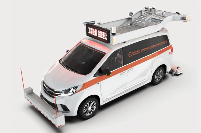
Vehicle‐Mounted GeoRadar 3D + 360° Camera + AI
Our vehicle‐mounted GeoRadar system integrates crossed 3D GPR antennas, a high‐definition 360° camera, and AI algorithms—all housed on a single vehicle. This combination delivers simultaneous surface and subsurface mapping at high speed, providing:
- Exclusive 3D Mapping Technology: Generates high-resolution, georeferenced subsurface images for accurate detection of buried utilities and structures.
- Wide Coverage per Pass: Up to 2 m of swath width per lane, reducing field time and operational costs.
- High Operating Speed: Data collection on roads and avenues at speeds up to 80 km/h, minimizing traffic impact and ensuring safety.
- Georeferenced 360° Imagery: A panoramic camera captures surface assets (grates, poles, manhole covers, etc.) in real time, integrating imagery and coordinates into a unified database.
- Real‐Time AI Processing: Machine‐learning models are trained to identify utilities, pavement classes, and anomalies—generating 3D maps and instant reports.
- High‐Density Subsurface Data: Crossed GPR antennas produce 3D subsurface images with high resolution, enabling detection of pipes, cables, and voids.
- Intuitive Interface: Embedded software displays the subsurface 3D view and 360° photos simultaneously, facilitating immediate decision‐making in the field.
- Safety and Efficiency: Inspections can be performed without interrupting traffic or requiring preliminary excavations, ensuring a complete map before any digging.
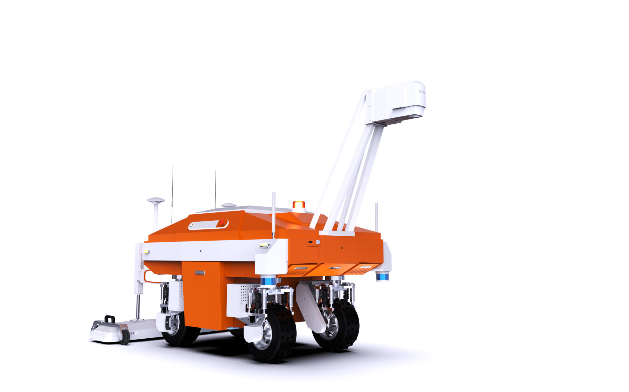
Autonomous GeoRadar Robot (3D + 360° + AI)
For missions that require high repeatability, access to narrow passages, or inspections in sensitive locations, we offer an autonomous GeoRadar robot. Equipped with 3D GPR antennas, a 360° camera, and onboard AI, this intelligent platform provides:
- SLAM‐Based Autonomous Navigation: Precise real‐time positioning—even in GPS‐denied environments—mapping complex trajectories inside tunnels, galleries, or narrow urban passages.
- High‐Resolution Scanning: Crossed antennas generate 3D detecting everything from high‐voltage cables to drainage pipes and potential voids.
- Intelligent 360° Capture: The camera automatically orients toward anomalies detected by GPR, adjusting angle and focus based on terrain, and stamps each frame with geographic coordinates.
- Safe Operation in Confined Spaces: LIDAR and sensors detect obstacles and maintain safe distances from sensitive structures, preventing operational risks.
- User-Friendly Interface: Simplified, intuitive 3D imaging ensures accessibility for professionals across various industries.
- Real-Time Visualization: Instantaneous processing for faster decision-making and on-the-spot interpretation.
- Full Integration with Our Data Hub: All data collected by the robot feeds directly into PaveVision, enabling dashboard views, BIM model generation, and export to engineering software (Civil 3D, Bentley, GIS, etc.).
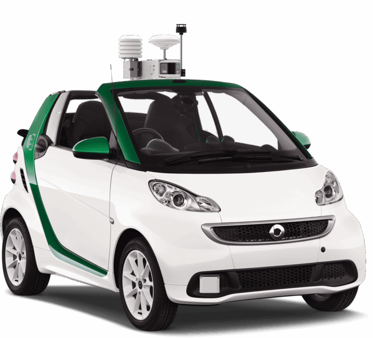
Vehicle‐Mounted Gas‐Leak Detection System
Complementing our infrastructure mapping suite, the vehicle‐mounted gas‐leak detection system continuously scans distribution networks in real time, delivering actionable insights to rapidly detect and address potential leaks, delivering:
- Advanced Laser Sensing: TDLAS sensors measure methane and other combustible gas concentrations from inside the cabin, even at speeds up to 60 km/h.
- Synchronized Multispectral Cameras: Correlate gas readings with thermal and 4K RGB imagery to pinpoint the exact leak location and assess environmental conditions.
- Centimetric Georeferencing: Each anomaly point is recorded with precise GNSS RTK coordinates, facilitating integration into GIS systems and standardized report generation.
- Onboard AI Processing: Algorithms filter out false positives (traffic interference, naturally occurring methane, etc.) and automatically generate risk maps for maintenance teams.
- Real‐Time Management Software: Embedded software issues visual and audible alerts in case of sudden concentration spikes, protecting the operator and speeding up response.
- Standardized Report Export: Automatically produces SIRT/Cakemapper reports compatible with asset‐management platforms, accelerating approval and remediation processes.
- User-Friendly Interface: Simplifies data visualization and interpretation, making it accessible for diverse teams.
- Real-Time Data Access: Instantly access updated inventory records for planning, reporting, and decision-making in the GasLeak app allowing teams to work together in real time, ensuring streamlined consistency across projects.
Why Choose Mapin?
By combining vehicle‐mounted 3D GeoRadar, autonomous robotics, and advanced gas‐leak detectors, Mapin delivers a comprehensive infrastructure mapping and monitoring platform that serves sectors such as:
- Highway and Railway Concessions: Rapid lane inspections and detection of structural anomalies without traffic interruptions.
- Water and Energy Utilities: Precise subsurface network mapping for expansion planning and preventive maintenance.
- Municipalities and Government Agencies: Urban street monitoring, gas‐leak detection, and continuous updates to city databases.
- Engineering and Construction Firms: BIM model generation, integrated geospatial analyses, and automated reporting for projects.
Key Benefits
- Enhanced Safety: Fewer manual interventions near subsurface utilities or gas networks.
- Cost & Time Savings: High‐speed data acquisition eliminates road closures and minimizes operational downtime.
- Data‐Driven Decisions: Georeferenced data with AI analysis produces ready-to-use reports for project planning and urban infrastructure development.
Join Our Journey
Connect with our team and stay informed with the latest advancements in infrastructure mapping innovative solutions. Subscribe to our newsletter for insights, updates, and exclusive content from Mapin.
